 Weather
 Locations
 Careers
 Login
Login

Drought and water update - August 2026
Drought monitor
Drought conditions worsened across the West, largely due to warmer-than-normal temperatures. Extreme drought conditions have expanded in eastern Oregon, southern Idaho and Utah, while other states advanced from D0 and D1 conditions to D2 and D3 (see map below). For the latest on weather, see AgWest’s Weekly Weather Updates with Eric Snodgrass.
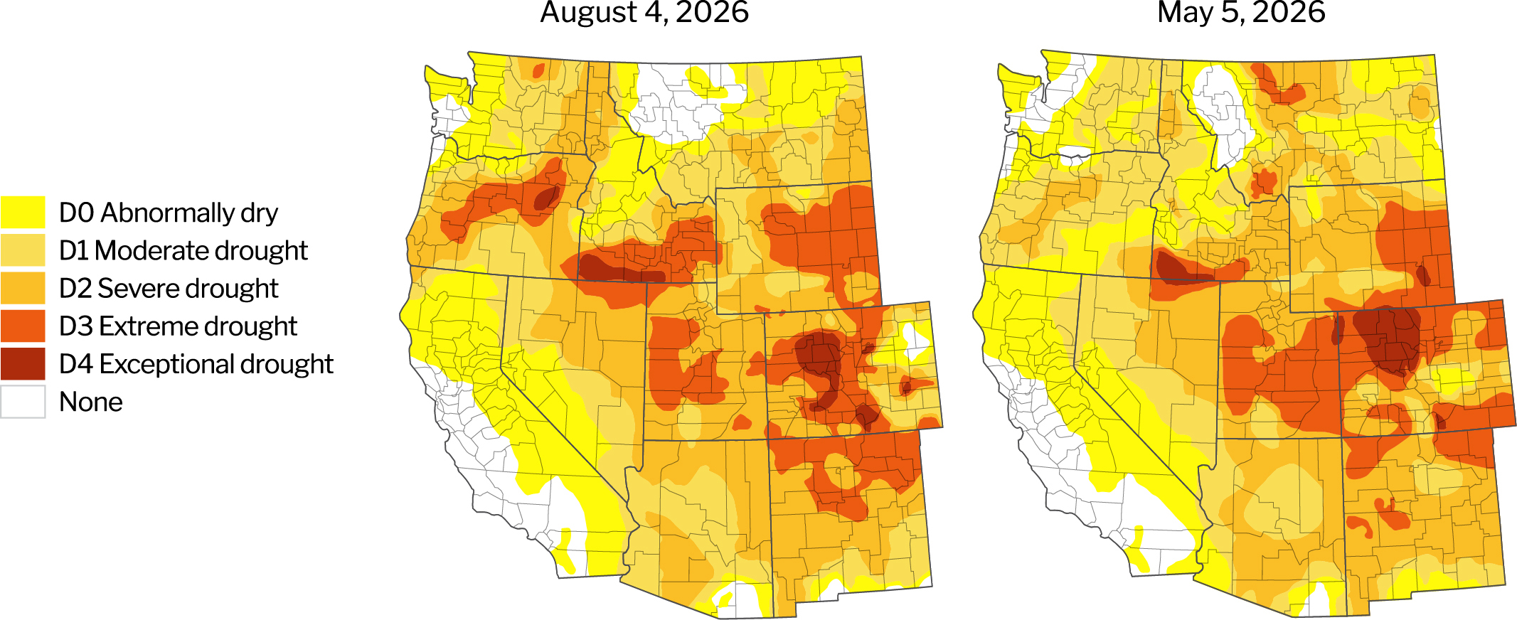
Source: U.S. Drought Monitor, University of Nebraska.
Description – The U.S. Drought Monitor provides a comprehensive look at drought conditions across the U.S., categorizing areas by intensity (no drought to Exceptional Drought). This tool helps agriculture producers understand water availability and make informed decisions about crop management.
Year-to-date precipitation
The West transitioned from a dry spring and low mountain snowpack to a wet, cool June. Despite improved precipitation in some basins, water availability remains a concern across much of the region especially as triple digit temperatures were experienced in July.
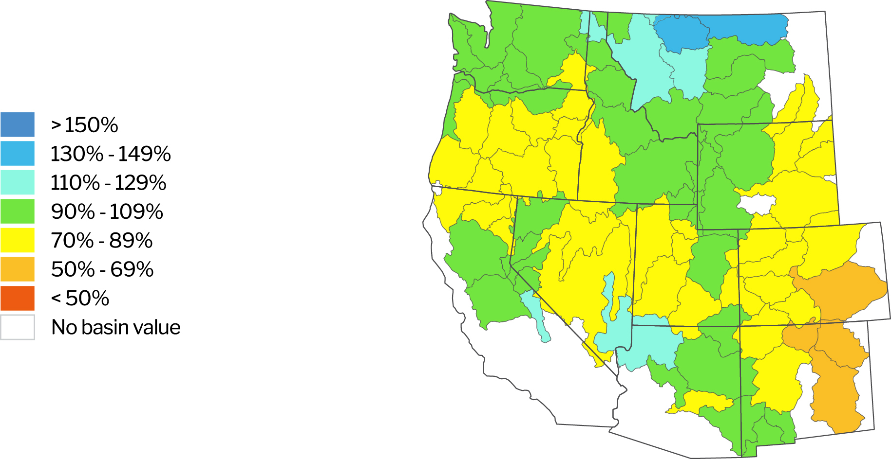
Source: Natural Resources Conservation Service. NWCC Interactive Map. Data as of Aug 4, 2026.
Description – The NWCC Year-to-Date Precipitation Map provides a detailed overview of precipitation levels across the U.S., comparing current data to a historical average. Similar to the Drought Monitor, this tool helps agriculture producers understand water availability and make informed decisions about crop management.
Reservoirs with low water levels
Reservoir levels have decreased throughout much of the West. Several reservoirs in Idaho and Oregon remain notably below average. Lake Powell and Lake Mead remain at historically low levels. California and Washington are the exceptions with most of their reservoirs at or above historical averages.
Reservoirs with water levels below 80% of their historical average
| Location/Region | Reservoir | Percent of average level | Percent of previous year |
|---|---|---|---|
| California | Pine Flat | 57% | 86% |
| Colorado River Basin | Lake Mead | 45% | 88% |
| Lake Powell | 33% | 72% | |
| Idaho | American Falls | 22% | 84% |
| Anderson Ranch | 75% | 98% | |
| Arrowrock | 33% | 70% | |
| Cascade | 74% | 94% | |
| Grassy Lake | 47% | 7% | |
| Island Park | 44% | 95% | |
| Lake Lowell | 77% | 102% | |
| Little Wood | 58% | 148% | |
| Mann Creek | 26% | 51% | |
| Palisades | 26% | 40% | |
| Reservoir A | 47% | 121% | |
| Ririe | 65% | 76% | |
| Soldiers Meadow | 55% | 121% | |
| Oregon | Agate | 40% | 37% |
| Beulah | 70% | 65% | |
| Crescent | 28% | 58% | |
| Emigrant | 38% | 38% | |
| Fish Lake | 21% | 18% | |
| Fourmile | 14% | 24% | |
| Hyatt | 66% | 48% | |
| McKay | 69% | 78% | |
| Ochoco | 60% | 64% | |
| Owyhee | 62% | 43% | |
| Prineville | 53% | 50% | |
| Phillips | 17% | 16% | |
| Thief Valley | 0% | 0% | |
| Unity | 38% | 44% | |
| Warm Springs | 54% | 32% | |
| Wickiup | 68% | 66% | |
| Washington | Cle Elum | 62% | 110% |
| Keechelus | 67% | 156% |
Source: Bureau of Reclamation: Reservoir Storage. California Department of Water Resources. Arizona Department of Water Resources.Data as of August 4, 2025.
Description – Reservoirs are an important source of water for agriculture producers throughout the West. This section identifies those with water levels at or below 80% of their historical average for the given period. Reservoirs at or above 80% of their historical average water levels are not included in this list.
Updates impacting water access
Arizona
Reservoir conditions remain critically low, with Lake Mead and Lake Powell at just 27% and 23% of capacity, respectively, raising concerns for agricultural water supplies and hydropower generation if water levels continue to decline. Drought concerns remain elevated as declining reservoir storage and ongoing water shortages continue to pressure agricultural water supplies. Nearly 90% of Arizona is currently classified as being in Moderate Drought (D1) or worse, although overall drought intensity has remained relatively stable over the past three months. June 2026 was Arizona’s seventh-hottest June on record. While localized storms delivered above-average rainfall to Sierra Vista, Tucson and Green Valley, these events provided only limited relief to broader water supply concerns.
Uncertainty surrounding the Colorado River’s long-term management continues to grow as seven states face an October 1 deadline to reach a formal operating agreement. After multiple failed attempts to negotiate, Upper Basin states (Colorado, New Mexico, Utah, and Wyoming) and Lower Basin states (Arizona, California, and Nevada) remain divided over how future water shortages should be allocated. In the meantime, federal officials appear willing to advance a temporary proposal from the Lower Basin states, which includes a combined 3.02 million acre-feet reduction in water use. Under the proposal, California would reduce consumption by 12%, Arizona by 31%, and Nevada by 38% until 2028. While many stakeholders hope the interim plan will prevent protracted legal battles, the potential for litigation remains.
The urgency of negotiations has increased as Colorado River water supplies continue to deteriorate. Conditions have been exacerbated by historically poor snowpack in the Rocky Mountain headwaters, limiting runoff into the system. The Colorado River supplies water to more than 35 million people and supports a regional agricultural sector that accounts for roughly 70% of total river water consumption. Future water allocation decisions will influence irrigation availability, crop production and water costs throughout the western United States.
California
California drought conditions have remained relatively stable the past three months. Late-season precipitation boosted reservoir storage and increased surface water allocations. The State Water Project allocation was raised from 30% to 45% following stronger-than-expected runoff and reservoir recharge. Federal water supplies also increased modestly, as the U.S. Bureau of Reclamation raised Central Valley Project allocations for South-of-Delta contractors from 20% to 25%.
Despite improved surface water supplies, groundwater management remains a major challenge. The State Water Resources Control Board continues advancing an interim groundwater management plan for the Tule Subbasin in southern Tulare County after determining local efforts failed to meet Sustainable Groundwater Management Act (SGMA) requirements. The basin remains on probation and could face significant pumping restrictions, particularly in areas experiencing severe subsidence or lacking access to surface water. Groundwater pumping fees were upheld for portions of southern Tulare County, reinforcing the state's use of regulatory and financial tools to bring overdrafted basins into compliance. The newly formed Tule East Groundwater Sustainability Agency has yet to implement pumping restrictions in areas where excessive groundwater withdrawals have contributed to damage along the Friant-Kern Canal corridor. Meanwhile, Kings County groundwater agencies have agreed to pursue a unified Groundwater Sustainability Plan to satisfy state requirements and avoid further intervention.
The cost of water compliance continues to rise for producers. The Yolo Subbasin Groundwater Agency approved new groundwater sustainability fees to fund management activities, while the Paso Robles Area Groundwater Authority adopted a groundwater pumping fee of $22.90 per acre-foot of consumptive use. These actions reflect the growing financial burden associated with achieving long-term groundwater sustainability.
Adding to water management concerns, Sacramento County recently declared a local emergency related to the spread of invasive golden mussels, which can clog water infrastructure, damage irrigation systems, and disrupt reservoir operations.
Overall, improved surface water supplies have strengthened California's near-term water outlook, but groundwater regulation, infrastructure development, rising compliance costs, invasive species threats, and Colorado River negotiations remain key issues for the state's agricultural sector.
Idaho
Drought conditions remain a significant concern across Idaho as producers enter the peak irrigation season. The state experienced its second-warmest winter on record, resulting in record-low snowpack and snow water equivalent levels on April 1. Earlier-than-normal snowmelt accelerated runoff and required reservoir operators to release water weeks ahead of the typical schedule, reducing late-season water supplies when demand is highest. As a result, irrigation shortages are emerging across several basins, particularly along the Snake River system.
Water availability concerns are now translating into significant delivery reductions for irrigators, with Twin Falls Canal Co. reducing water deliveries by 33.3%. North Side Canal Co. and American Falls Reservoir District No. 2 are also each implementing 20% cuts; Minidoka Irrigation District is reducing deliveries by 15%; and Milner Irrigation District is reducing deliveries by 12%. Compounding these challenges, the Upper Snake River storage is at 29% of capacity and the Idaho Department of Water Resources recently issued a notice regarding potential curtailments under trust water rights as declining Snake River flows threaten minimum flow requirements established under the Swan Falls Agreement. These trust water rights were granted after the agreement and are subject to maintaining minimum flows for hydropower generation, highlighting the growing competition for limited water supplies among agricultural, municipal, and energy users.
Montana
Drought conditions remained a significant concern across Montana, although scattered precipitation brought brief relief to localized areas. The north-central portion of the state received two significant rainfall events in late May and again in late June. The Golden Triangle area received approximately four inches of rain in late May over a several day period, followed by approximately two more inches of rain over another several day period. This significantly eased drought concerns in north-central Montana. As a result, irrigation water concerns have eased in this area for the time being, although persistent heat through the end of July is drying the area out quickly. While north-central Montana received considerable rain, other areas of the state remain dry. Drought conditions have been driven by a combination of below-normal snowpack, early snowmelt, and persistent moisture deficits. Water supply forecasts indicate below-average streamflows and continued concerns over reservoir storage in several basins, particularly as irrigation demand peaks during the summer growing season.
Montana is now facing its sixth consecutive year of abnormally dry spring and summer conditions, increasing concerns about irrigation supplies, streamflows, forage production, and late-season water availability. Snow at elevations below 6,500 feet melted roughly one month earlier than normal, accelerating runoff and reducing the amount of water available later in the summer.
Adding to these challenges, eastern Montana experienced an intense July heatwave that pushed temperatures to record or near-record levels. Glendive, Billings, and Miles City each reached over 110°F on July 12. Temperatures of this magnitude are relatively rare in Montana. The area has remained very hot and windy through the end of July, further complicating drought conditions. The Tongue River is at 67% of its normal flow for this time of year and other rivers in the area are at nearly the same flow level. The combination of prolonged drought and extreme heat accelerated crop water demand, stressed rangelands, and heightened wildfire concerns across many parts of the state. Montana has seen more than 120 new wildfires start in the past few weeks, primarily within the western half of the state.
Water shortages are increasingly affecting agricultural operations across the state. For the second consecutive year, producers served by the Camas Canal Unit of the Flathead Indian Irrigation District received very limited irrigation water allocations. The district relies on water stored in Little Bitterroot Lake and Hubbart Reservoir in Flathead County, where ongoing drought conditions have constrained available supplies. Reduced water deliveries have heightened concerns for hay, grain, and livestock producers dependent on irrigation during the peak growing season. Many producers have already adjusted irrigation schedules, reduced planted acreage, or relied more heavily on supplemental feed as forage production prospects have deteriorated in some regions.
Beyond immediate water supply concerns, access to and management of water resources continues to be a prominent issue across the state. Ongoing disputes over water access in the Crazy Mountains region underscore the increasing value of water throughout Montana as supplies become more constrained. As drought conditions persist and competition for limited water resources intensifies, balancing agricultural, municipal, recreational, and environmental water demands is becoming increasingly challenging.
With many areas entering August carrying significant moisture deficits, water availability is expected to remain a key risk factor for Montana agriculture through the remainder of the growing season and into 2027. Producers will be closely monitoring late-summer precipitation, reservoir levels, and rangeland conditions.
Oregon
Drought conditions continued to worsen across Oregon during July as exceptionally low snowpack and persistent warmth further strained water supplies. As of August 6, 88% of the state is currently experiencing moderate drought (D1) or worse, while 57% is classified as being in severe drought (D2) or greater. Drought impacts are widespread, with 21 of Oregon's 36 counties operating under drought declarations.
Water availability is a growing concern entering the second half of the irrigation season. Water year-to-date streamflows are running below to well below normal across most major river basins, with some of the largest deficits occurring in southwestern and eastern Oregon. Conditions deteriorated further between May and June as the limited snowpack that remained in the mountains melted rapidly and was not replenished by spring precipitation. Forecasts for June through September suggest streamflows across much of Oregon will rank among the lowest 15% of the historical record, increasing the likelihood that some rivers and streams could approach or fall below historic lows by late summer.
The state's water challenges stem largely from one of the lowest snowfall years on record. By June 1, snowpack had completely melted from all monitored snow stations, marking the earliest statewide melt-out in more than a decade and occurring more than a month earlier than normal in both the Cascade and Blue Mountain ranges. Mountain snowpack levels fell to near 40-year lows in many locations. Persistent above-normal temperatures from November through May caused much of the winter's precipitation to fall as rain rather than snow, even at higher elevations. The lack of mountain snow storage has reduced summer water availability, increased pressure on reservoirs and streamflows, and heightened wildfire concerns across the state.
Reservoir storage levels reflect these ongoing challenges. Of Oregon's 46 monitored water basins, 36 are currently below 80% of water storage capacity, leaving many regions vulnerable to additional stress if hot and dry weather persists through August and September.
While portions of central, eastern, and northwestern Oregon received precipitation during the latter half of July, much of the benefit was offset by above-normal temperatures that accelerated evaporation and increased crop water demand. Looking ahead, forecasts call for continued above-normal temperatures and below-normal precipitation across much of the state through early August. Wildfires have impacted more than 2 million acres in central and eastern Oregon and remain an ongoing concern.
Washington
Washington's water supply outlook has deteriorated significantly following an exceptionally low snowpack and rapid spring snowmelt. Record-low winter snowpack levels across much of the state led to widespread early melt-out conditions during April and May, with many monitoring stations recording their earliest snow disappearance dates on record. As a result, water supply forecasts are trending below normal to well below normal, with several basins projected to experience streamflows near historic lows, raising concerns about water availability throughout the summer irrigation season.
As of June 1, statewide snow water equivalent (SWE) averaged just 17% of normal, with all major basins except the Spokane Basin reporting below-average snowpack conditions. While peak runoff temporarily supported reservoir recharge and streamflow levels during late spring, the limited snowpack has now largely melted, leaving water supplies increasingly dependent on summer precipitation. Additional rainfall will be critical to maintaining streamflows and limiting further declines in reservoir storage through the remainder of the growing season.
Drought conditions have continued to intensify across the state. As of August 6, 63% of Washington was classified as being in moderate drought (D1) or worse, an increase of 20% over the past three months. Conditions have worsened across eastern and central Washington, while drought has also expanded into portions of the Olympic Peninsula. The combination of hot, dry conditions, limited moisture and high winds has fueled several significant fires across central and eastern Washington, which have burned more than 450,000 acres and led to the evacuation of over 60,000 people.
Looking ahead, climate forecasts call for above-normal temperatures and below-normal precipitation during the next three months. Without substantial rainfall, water supplies are expected to remain strained, increasing pressure on agricultural producers, municipal water systems, and natural ecosystems across much of the state.
Return to Industry Insights home page
IN THIS SECTION

.jpg?Status=Master&sfvrsn=68087301_1 "My project-1 (26)")
Economic headlines, data and trends
Monthly economic trends, data and major industry headlines.
Learn more