Drought and water update - February 2026
Drought monitor
Drought conditions improved significantly across the West, largely due to heavy precipitation in December. California is completely out of drought, while other states experienced a retreat from D2 and D3 conditions to D0 and D1 (see map below). For the latest on weather, please see AgWest’s Weekly Weather Updates with Eric Snodgrass.
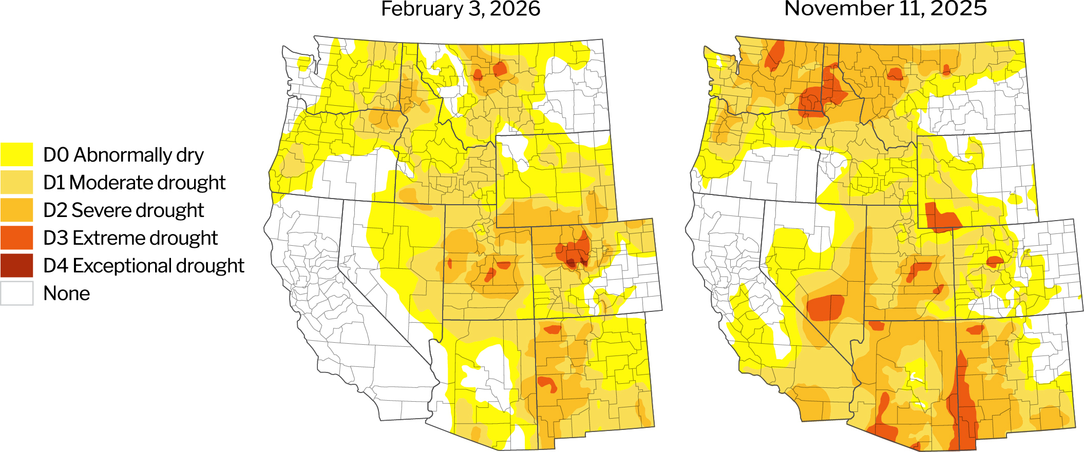
Source: U.S. Drought Monitor, University of Nebraska.
Description – The U.S. Drought Monitor provides a comprehensive look at drought conditions across the U.S., categorizing areas by intensity (no drought to exceptional drought). This tool helps agriculture producers understand water availability and make informed decisions about crop management.
Year-to-date precipitation
While the West experienced heavy precipitation levels in December, the region returned to dry conditions in January. Mountain snowpack is at very low levels for this time of year and this may reduce water availability later in the season.
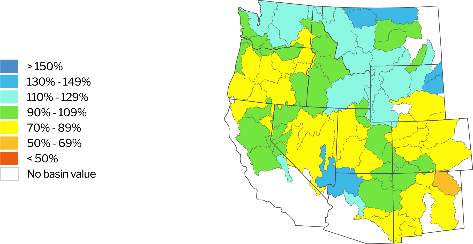
Source: Natural Resources Conservation Service. NWCC Interactive Map. Data as of February 5, 2026.
Description – The NWCC Year-to-Date Precipitation Map provides a detailed overview of precipitation levels across the U.S., comparing current data to a historical average. Similar to the Drought Monitor, this tool helps agriculture producers understand water availability and make informed decisions about crop management.
Reservoirs with low water levels
Reservoir levels have improved throughout the West, with those in California and Washington all at or near their historical averages. Several reservoirs in Idaho and Oregon remain notably below average. Lake Powell and Lake Mead levels remained steady.
Reservoirs with water levels below 80% of their historical average
| Location/Region | Reservoir | Percent of average level | Percent of previous year |
|---|---|---|---|
| Colorado River Basin | Lake Powell | 42% | 74% |
| Lake Mead | 54% | 99% | |
| Idaho | Mann Creek | 71% | 59% |
| Palisades | 62% | 61% | |
| Oregon | Cold Springs | 70% | 95% |
| Crescent Lake | 47% | 148% | |
| Emigrant | 62% | 68% | |
| Fourmile Lake | 53% | 85% | |
| McKay | 65% | 52% |
Source: Bureau of Reclamation: Reservoir Storage. California Department of Water Resources. Arizona Department of Water Resources. Data as of February 4, 2025.
Description – Reservoirs are an important source of water for agriculture producers throughout the West. This section identifies those with water levels at 80% or below of their historical average for the given period. Reservoirs at or above 80% of their historical average water levels are not included in this list.
Updates impacting water access
United States
A federal judge in California paused the Trump Administration’s plan to lay off more than 2,000 people in the Department of Interior (DOI). The prospect of layoffs would come as funding freezes to activities under the Inflation Reduction Act were already impacting various water conservation efforts and infrastructure projects across the West.
Arizona
Conditions improved significantly over the last few months, with about 30% of the state now out of drought and a significant portion moving from D2 and D3 classification levels to D1 and D0. Despite these improvements, snow water equivalent levels are significantly below average. Lake Mead and Powell are well below their historical averages and unlikely to improve much over the coming months. The Colorado Basin is expected to be in a Tier 1 shortage again, meaning Arizona will face a 512,000 acre-feet reduction in total supply from normal levels. Arizona faced Tier 1 shortage conditions in 2025.
The Colorado River Basin states did not come to a voluntary agreement to replace the expiring Colorado River Compact, which regulates water use from the Colorado River, by the Nov. 11 deadline. The Bureau of Reclamation extended the deadline to February 14 and drafted an environment impact statement with options moving forward to be reviewed by the basin states. Colorado River Compact negotiations remain tense and ongoing between lower basin states (Arizona, California and Nevada) and upper basin states (Colorado, New Mexico, Utah and Wyoming). A meeting between Colorado Basin governors and Interior Secretary Doug Burgum in Washington D.C. on January 30, 2026 went reportedly well. As of February 5, 2026, no agreement has been reached.
A novel, voluntary agreement between Arizona’s Attorney General and a dairy farm was reached in January. The farm agreed to reduce its groundwater usage, fallow or convert 2,000 acres of irrigated farmland and establish two funds valued at $5.5 million each to support water access for nearby residents. This agreement may open the way for more collaborative approaches to water conservation in Arizona.
The Ranegras Plain Groundwater Basin was designated as Arizona’s 8th Active Management Area (AMA) in response to significant groundwater declines. AMAs place significant water use limits, monitoring and compliance standards on producers.
The Colorado River Indian Tribes, Gila River Indian Community and Central Arizona Water Conservation District (CAWCD) have reached an agreement for greater cooperation in managing and addressing Colorado River issues, including shortages, river restoration and a long-term drought. CAWCD manages the Central Arizona Project.
California
Conditions improved significantly in the Southwest of California over the last few months, and the state is now completely drought free. Reservoir levels are at or above average levels. Despite these positive developments, snow water equivalent levels remain significantly below average in the northern half of the state. Low snowpack levels could negatively impact water availability and/or reservoir recharge later in the season.
Department of Water Resources (DWR) announced an increase to the State Water Project (SWP) allocation to 30% of requested supplies, up from the initial 10% estimate. Allocations at this time of the season typically range from 15% to 30% based on existing hydrological conditions, current reservoir storage and assumptions about how conditions will change over the season.
The Bureau of Reclamation announced a series of revisions to the Central Valley Project (CVP) to increase water deliveries. Revisions include removing certain conservation rules and relaxing minimum streamflow criteria. Approximately 130,000 – 180,000 acre-feet of additional water should become available to producers in the Central Valley.
A Kern County Superior Court Judge ruled that Section 5901 cannot be enforced by private parties, removing one cause of action in an ongoing lawsuit between Bring Back the Kern and City of Bakersfield. Section 5901 makes it illegal to construct or maintain any device or structure that impedes fish passage. As a result, the lawsuit’s scope is reduced to whether dam operators provide sufficient water for fish passage under Fish and Game Code 5937, which will be contested in a trial beginning in February 2027.
The South Fork Kings Groundwater Sustainability Agency (SFKGSA) approved a pumping allocation, allowing Lemoore-area pumpers to extract a base amount of 0.86 acre-feet per acre of land once all transitional allocations are phased out by 2040. Enforcement fees will not be imposed in the 2026 water year to give farmers time to transition to measuring their use and managing their allocation. SFKGSA is located in the Tulare Lake Subbasin, which remains under Probation with the State Water Resources Control Board and may face sharper restrictions if the Board deems current plans insufficient. Litigation against the Board’s authority to enforce their own restrictions continues to unfold.
The Tule Subbasin is also under probation, with mitigation of subsidence (ground sinking due to declining water table) becoming a key sticking point. Groundwater regulators are enacting very tight pumping restrictions in subsidence prone areas, such as land in the vicinity of the Friant Kern Canal. Meanwhile, several new groundwater sustainability agencies have formed after splitting off from others due to manifold disagreements, complicating coordination efforts to exit Probation and avoid state intervention.
The State Water Resources Control Board approved a 25-year extension of the Lower Yuba River Accord (Accord), to remain in effect through 2050. In addition to providing water to agricultural communities served by Yuba County Water Agency, Westlands Water District has received approximately 250,000 acre-feet under the Accord since 2008. The Accord allows water released for environmental benefit available for purchase by downstream users and groundwater to be used instead of surface water. Surface water can be transferred through a conjunctive use approach to improve flexibility.
The Department of Interior signed off on the environmental review process (called Record of Decision) for Sites Reservoir Project, a proposed 1.5-million acre-foot off-stream reservoir north of Sacramento. The reservoir will eventually provide water to 500,000 acres of farmland and 24 million people.
The Court of Appeal for the Third Appellate District upheld a Sacramento County judge’s 2024 decision that DWR lacks the authority to issue bonds to fund the $20 billion Delta Conveyance Project. The project is designed to improve how California captures and stores water during wet years to use in dry years. This ruling will delay how the project is funded.
The Ninth Circuit Court of Appeals overturned a judge’s order that required San Luis Obispo County to release more water from Lopez Lake into Arroyo Grande Creek. While environmental groups argued this would help protect steelhead trout, which is protected under the Endangered Species Act, county officials argued it would negatively impact other protected species.
Idaho
Drought conditions improved modestly in Northern Idaho over the last several months, where D3 and D2 classification levels fell to D1 and D2. Snow water equivalent levels range from 53% to 83% across Idaho, which faces what many are calling a snow drought. While reservoir levels are at or near average levels, limited snowpack may reduce water availability later in the season.
The Idaho Department of Water Resources (IDWR) found a shortfall of 65,824 acre-feet to Twin Falls Canal Co. and 20,932 acre-feet to the American Falls Reservoir District #2. Below normal precipitation resulted in significant storage water use in 2025. In total, 1,500–2,000 junior ground rights may be impacted.
Adjudication is underway or about to begin in North and Southeast Idaho, with the goal of making a comprehensive recording of surface and groundwater rights in the regions. This process will help users claim their water rights.
Montana
Drought conditions improved notably over the last three months, with a significant portion of the state moving from D2 and D3 to D0 and D1 level classifications. However, Great Falls and the Golden Triangle continue to face intense drought conditions. About 56% of the state is in some form of drought, down from 68% in November. Snow water equivalent levels generally range from 76% to 86% for much of the state. Producers may face challenges later in the season if snowpack doesn’t increase over the coming months. Northwest Montana faced flooding in December, resulting in washed out bridges.
A broad coalition of plaintiffs has filed a lawsuit against the State of Montana, arguing that the state’s handling of exempt well regulations has improperly favored residential development at the expense of senior water rights holders and aquatic ecosystems. Plaintiffs contend that the state’s interpretation of the exempt well law allows too much unregulated groundwater withdrawal, contributing to declining stream flows and impairing senior water users who legally hold priority rights to water.
The Montana Department of Environmental Quality (DEQ) moved away from using numerical limits for nutrient pollution to narrative nutrient criteria, a qualitative method of assessing the environmental impacts of various human related activities. While this policy creates flexibility by allowing for site-specific assessments, it faced criticism from conservation groups who argue it weakens pollution controls by moving from a proactive to reactive approach.
Oregon
Drought conditions improved moderately over the last three months. Overall reservoir levels remain favorable, though improvements in December were short lived as precipitation gave way to dry conditions in January. Outside of the coast, snow water equivalent levels range from 24% to 40% of average and this could lead to lower water availability in the summer.
Governor Tina Kotek established a new Data Center Advisory Committee in response to the rapid growth of data centers across the state and rising concerns about their energy and water impacts. Data centers require significant water resources for cooling, which can stress supplies and raise costs. The committee will develop recommendations for site regulations.
The Oregon Water Resources Commission designated the Harney Basin a critical groundwater area due to declining groundwater levels. The designation will result in tighter oversight and permissible withdrawals are likely to fall 35% on average, with some subbasin’s potentially reaching as high as 75% over 30 years.
Washington
Drought conditions have improved drastically over the last three months, with a significant portion of the state moving from D2 and D3 to D0 and D1 level classifications. Heavy precipitation levels in December brought reservoirs to or above average levels. Despite these improvements, snowpack remains well below average due to warmer than average weather and limited precipitation in January. This could reduce water availability later in the summer.
Irrigation District customers have seen water restrictions for the past three years due to drought conditions. While restrictions will continue into 2026, there is optimism that water allowances should be better than 2025. However, the level of allowance is dependent on the snowpack over the next 45-60 days and spring precipitation. Early January reports indicated snowpack is 55% of average for the Yakima River mainstem and 66% of average on the Naches River arm. Reservoir storages are at 64% of capacity.
Return to Industry Insights home page
IN THIS SECTION
![]()
.jpg?sfvrsn=68087301_1 "My project-1 (26)")
Economic headlines, data and trends
Monthly economic trends, data and major industry headlines.
Learn more