 Weather
 Locations
 Careers
 Login



Interest rate outlook updates
Get timely, ag-related updates, directly following the release of major economic reports, in our ongoing series with Dr. Ed Seifried, economist, university professor and nationally recognized speaker and author.

Updates from The Fed
Following each Federal Open Market Committee (FOMC) meeting, Dr. Seifried provides an overview of decisions and an interpretation of the broader economic implications to agricultural producers and the marketplace.

Economic headlines, data and trends
Monthly economic trends and major industry headlines.

Agricultural Trends
Check out these videos and articles developed specifically for agricultural producers by Dr. Kohl, who has a Ph.D. in Agricultural Economics from Cornell University and decades of experience working with agricultural operations and business owners.


Market update reports
Interested in receiving more reports like this? Click subscribe to sign up for the Monthly Market Update where you will find monthly, quarterly and biannual reports delivered straight to your inbox.
Drought and water update - November 2026
Drought monitor
Drought conditions improved across much of the West over the past three months. Referencing the maps below, the amount of the West in D3 (extreme drought) or greater was cut in half. The Southwest experienced favorable monsoons, additional moisture from El Nino-driven hurricanes in the Pacific, and higher elevation snows. Southern Idaho, central Washington and western Montana also saw improvement. For the latest on weather, see AgWest’s Weekly Weather Updates with Eric Snodgrass.
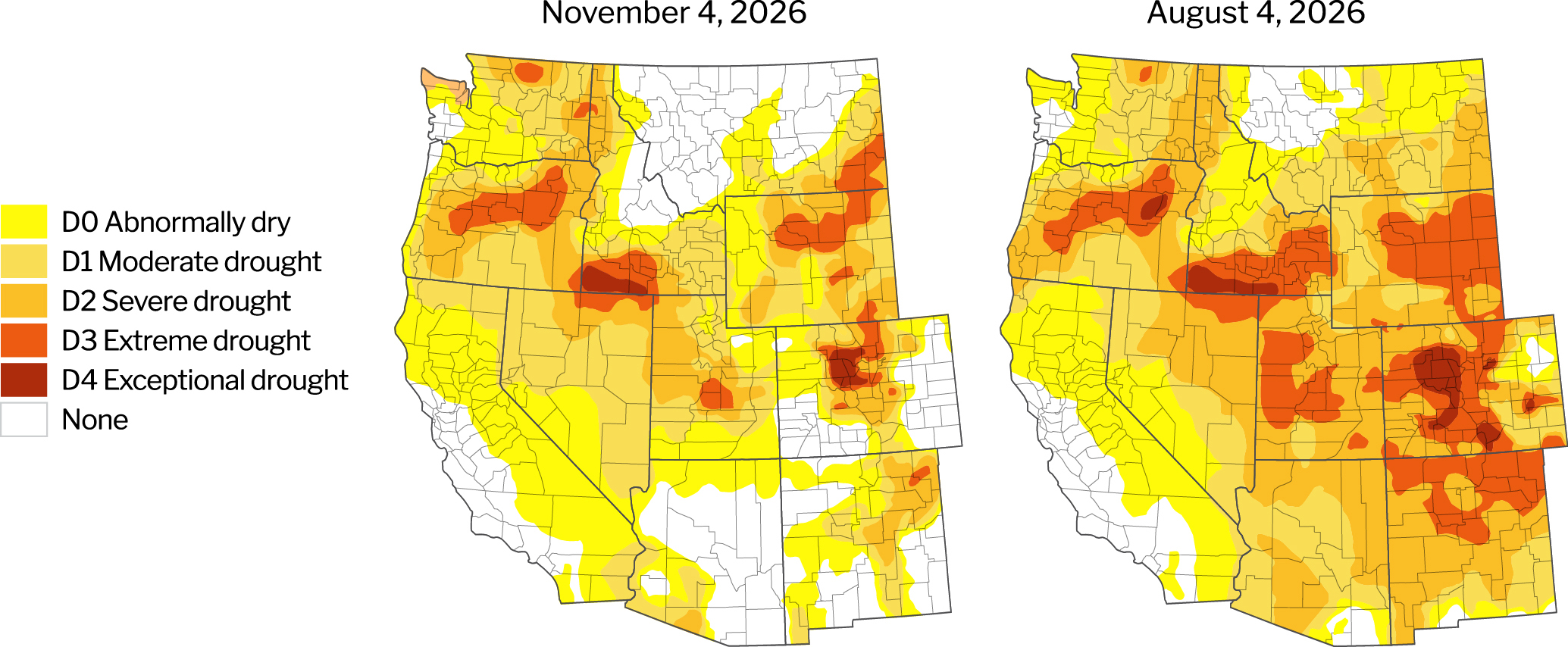
Source: U.S. Drought Monitor, University of Nebraska.
Description – The U.S. Drought Monitor provides a comprehensive look at drought conditions across the U.S., categorizing areas by intensity (no drought to Exceptional Drought). This tool helps agriculture producers understand water availability and make informed decisions about crop management.
Year-to-date precipitation
Since the water year began on Oct. 1, precipitation has been highly uneven across the West, accelerating drought improvement in the Southwest while providing less relief to the Pacific Northwest. Arizona entered the new water year following beneficial monsoonal rainfall and additional moisture from Pacific tropical systems. Hurricanes Odalys and Polo delivered 5 to 10 inches of rain in parts of the Southwest, followed in October by rain and early-season mountain snow associated with Hurricane Rachel. The Pacific Northwest has not seen comparable precipitation, with many areas missing the season's heaviest storms and remaining well below normal early in the water year.
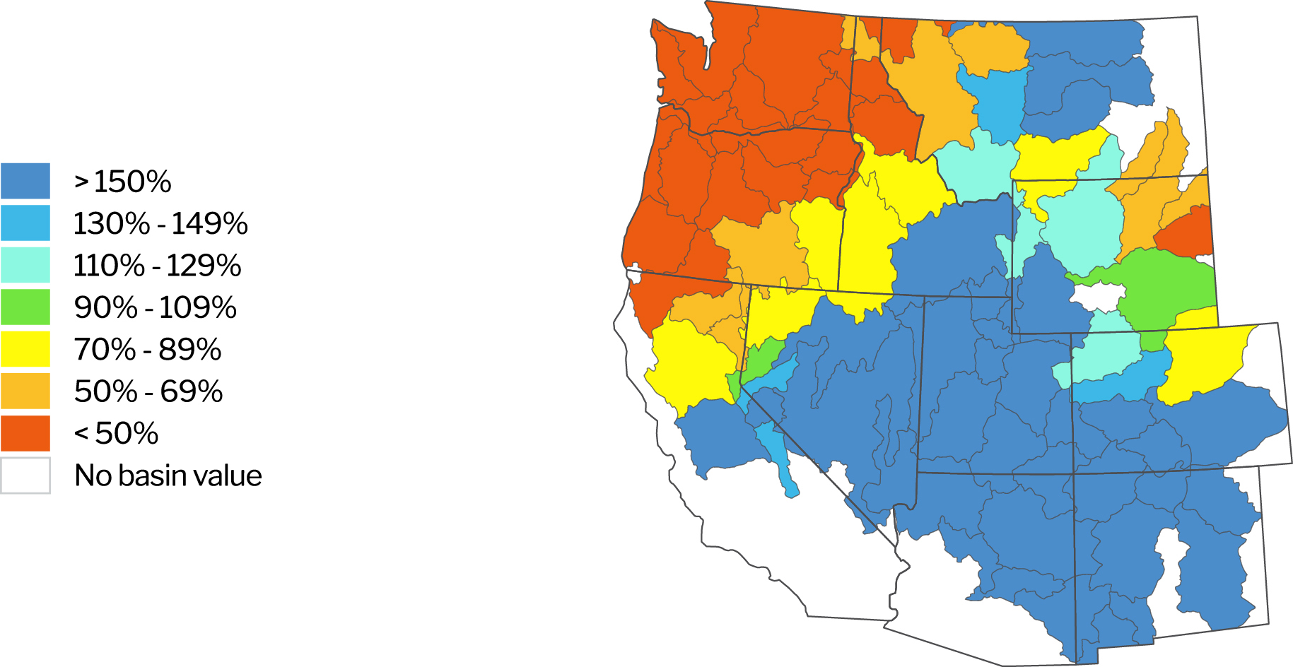
Source: Natural Resources Conservation Service. NWCC Interactive Map. Data as of Nov 4, 2026.
Description – The NWCC Year-to-Date Precipitation Map provides a detailed overview of precipitation levels across the U.S., comparing current data to a historical average. Similar to the Drought Monitor, this tool helps agriculture producers understand water availability and make informed decisions about crop management.
Reservoirs with low water levels
Reservoir levels have decreased throughout much of the West. Several reservoirs in Idaho and Oregon remain notably below average. Lake Powell and Lake Mead remain at historically low levels. California and Washington are the exceptions with most of their reservoirs at or above historical averages.
Reservoirs with water levels below 80% of their historical average
| Location/Region | Reservoir | Percent of average level | Percent of previous year |
|---|---|---|---|
| California | Pine Flat | 66% | 74% |
| Colorado River Basin | Lake Mead | 39% | 83% |
| Lake Powell | 35% | 77% | |
| Idaho | American Falls | 22% | 84% |
| Grassy Lake | 63% | 71% | |
| Island Park | 44% | 95% | |
| Jackson Lake | 16% | 15% | |
| Lake Walcott | 42% | 62% | |
| Mann Creek | 16% | 37% | |
| Palisades | 28% | 111% | |
| Reservoir A | 82% | 106% | |
| Ririe | 67% | 60% | |
| Soldiers Meadow | 67% | 100% | |
| Oregon | Beulah | 46% | 28% |
| Bully Creek | 66% | 34% | |
| Crescent | 17% | 39% | |
| Emigrant | 41% | 51% | |
| Fish Lake | 64% | 50% | |
| Fourmile | 23% | 76% | |
| Hyatt | 66% | 46% | |
| Ochoco | 52% | 30% | |
| Owyhee | 42% | 25% | |
| Prineville | 43% | 42% | |
| Phillips | 1% | 1% | |
| Scoggins | 66% | 109% | |
| Thief Valley | 0% | 0% | |
| Unity | 60% | 66% | |
| Warm Springs | 21% | 10% | |
| Wickiup | 49% | 47% | |
| Washington | Bumping | 34% | 47% |
| Cle Elum | 18% | 73% | |
| Kachess | 63% | 211% |
Source: Bureau of Reclamation: Reservoir Storage. California Department of Water Resources. Arizona Department of Water Resources.Data as of November 4, 2026.
Description – Reservoirs are an important source of water for agriculture producers throughout the West. This section identifies those with water levels at or below 80% of their historical average for the given period. Reservoirs at or above 80% of their historical average water levels are not included in this list.
Updates impacting water access
Arizona
Drought and water supply concerns remain elevated across Arizona as the state enters the 2027 water year. Record warmth and exceptionally poor snowpack across the Intermountain West during 2026 resulted in well-below-normal runoff and further depleted Colorado River supplies. Natural streamflow into Lake Powell during the 2026 water year was just 37% of normal, while late-season precipitation provided localized drought relief but was not enough to erase longer-term water supply deficits.
Conditions across the Colorado River system remain particularly concerning. Lake Powell and Lake Mead both reached record-low elevations in August, pushing their combined storage to its lowest level since before Lake Powell began filling in 1963. By mid-October, Lake Mead was approximately 26% full. These historically low storage levels leave the river system increasingly vulnerable to another poor snow and runoff year, and continue to raise concerns about future agricultural water availability and hydropower generation.
Under the federal framework, Arizona, California and Nevada collectively face 1.25 million acre-feet of reductions in both 2027 and 2028, including 760,000 acre-feet annually for Arizona. Arizona and Nevada have challenged the federal approach, while the Lower Basin states continue discussing how reductions should be distributed before changes to downstream deliveries take effect. For Arizona agriculture, the dispute adds another layer of uncertainty to an already constrained water outlook. Tighter supplies could contribute to fewer harvested acres in forage-producing areas as producers adjust acreage and water use.
Groundwater availability is also becoming a more pressing issue in parts of southeastern Arizona. In the San Simon Valley, state water officials estimate that the groundwater basin is losing 50,000 acre-feet more water each year than is naturally replenished. Local farmers have petitioned the Arizona Department of Water Resources to establish an Irrigation Non-Expansion Area, which would prohibit irrigation of new agricultural acreage but would not reduce pumping on land already in production. State data also shows that groundwater declines have accelerated alongside agricultural development, while portions of the valley have experienced land subsidence as the aquifer is depleted.
Looking ahead, the strengthening El Niño offers some potential relief, but considerable uncertainty remains. NOAA's 2026–27 U.S. Winter Outlook favors wetter-than-average conditions across the Southwest, and drought improvement is expected across portions of the region. However, a wetter winter alone will not resolve the Colorado River's water supply challenges. The October 2026 Intermountain West Drought Status Update notes that meaningful hydrologic recovery will require sufficient spring runoff from mountain snowpack and that even a strong precipitation year would not fully replenish critically low major reservoirs.
Overall, Arizona enters the 2027 water year facing historically low Colorado River storage and potentially significant reductions in future deliveries. A wetter El Niño winter could provide some relief, but rebuilding Rocky Mountain snowpack and generating strong spring runoff will be critical to improving the region's water outlook and limiting further pressure on agricultural water supplies.
California
California enters the 2027 water year with a mixed water supply outlook. The 2026 water year brought near-normal precipitation across much of California and Nevada, but precipitation was heavily concentrated early in the season, followed by a much drier January through March. Temperatures ranked among the warmest 10% of water years, contributing to poor snowpack and exceptionally early snowmelt. Drought conditions improved across central and southern California over the course of the water year, while conditions deteriorated farther north.
Surface water supplies improved during the 2026 season. The State Water Project allocation increased as conditions evolved, while the U.S. Bureau of Reclamation ultimately raised Central Valley Project allocations for South-of-Delta irrigation contractors to 28% of their contract supply in August, up from 20% in March and 25% in May. In late October, the allocation increased from 28% to 31%, an unusual late-season adjustment reflecting available reservoir supplies. For Westlands Water District, the additional allocation represents roughly 37,450 acre-feet and could reduce groundwater pumping by a similar amount.
The contrast between surface-water and groundwater conditions remains significant. While some major surface-water supplies entered fall in relatively strong positions, groundwater overdraft, subsidence and Sustainable Groundwater Management Act (SGMA) implementation continue to create challenges across parts of the Central Valley. Local agencies have identified nearly 500 groundwater recharge projects and management actions, including 331 projects with projected benefits totaling approximately 1.52 million acre-feet annually.
The cost of groundwater management is also becoming increasingly tangible for producers. In the Tulare Lake subbasin, the Mid-Kings River Groundwater Sustainability Agency approved a $26.84-per-acre annual assessment and a groundwater pumping fee that will rise to $19.24 per acre-foot in 2028 as the agency works to improve its groundwater sustainability plan and address subsidence and domestic-well concerns. The subbasin has been under state probation since 2024, reinforcing the financial and regulatory consequences facing areas that do not demonstrate sufficient progress toward groundwater sustainability.
Looking ahead, a strengthening El Niño creates both opportunity and risk for California's 2027 water outlook. El Niño is expected to tilt the odds toward increased precipitation, which could help improve drought conditions and create opportunities to replenish depleted groundwater supplies. However, the benefit will depend on temperatures and the timing and intensity of storms. California water managers are preparing for the possibility of high-flow events, with the state emphasizing groundwater recharge as one way to capture excess water while reducing flood impacts.
Overall, California begins the 2027 water year in a better near-term surface-water position than conditions earlier in 2026 might have suggested, but improved reservoir supplies do not eliminate the state's longer-term water challenges. Groundwater overdraft, subsidence, rising SGMA compliance costs, and uncertainty surrounding future Delta operations remain important issues for agriculture. A wetter El Niño winter could provide an important opportunity to rebuild supplies, but how much precipitation falls as snow, how quickly that snow melts, and California's ability to capture high flows for reservoir storage and groundwater recharge will ultimately determine how much the water outlook improves heading into the 2027 growing season.
Idaho
Drought and water availability remain significant concerns across Idaho as the state enters the 2027 water year. An unusually warm 2025–26 winter contributed to poor snowpack and early snowmelt, leaving limited runoff available to replenish reservoirs and sustain irrigation water supplies through the summer. The impacts were particularly pronounced across the Upper Snake River Basin, where low reservoir storage forced irrigation districts to conserve water and reduce deliveries during the growing season.
While the irrigation season is now largely complete, Idaho enters the new water year with a substantial water supply deficit. As of mid-October, the Upper Snake River reservoir system was only about 9% full, compared with a median season-ending minimum of roughly 38%. The system approached historically low levels despite conservation efforts by irrigators, highlighting how heavily storage was drawn down during the 2026 growing season. Irrigators dependent on the Snake River largely exhausted available storage, increasing the importance of winter precipitation and reservoir recharge ahead of the 2027 growing season.
As irrigation demand tapered off in mid-October, the Upper Snake River reservoir system's seasonal drawdown ended and the winter storage season began, with storage starting to rise as natural flow exceeded declining deliveries. Rain in mid-October likely added to that early recovery. Even so, starting the storage season at such low levels leaves a substantial amount of ground to make up before next year's irrigation season.
Looking ahead, rebuilding reservoir storage and mountain snowpack will be critical to Idaho's 2027 water outlook. Water managers are working to capture more water in upstream reservoirs during the offseason. A strong snow accumulation season would help replenish the Upper Snake system and improve water availability ahead of spring, while another poor snow year could leave irrigators facing continued water supply constraints in 2027.
Montana
Drought conditions have improved across much of Montana, supported by a relatively wet start to fall. September precipitation averaged 2.18 inches statewide, 0.72 inches above normal, while an early-season winter storm brought heavy, wet snow to north-central and southwestern Montana on Oct. 10-11. Remnant moisture from Hurricane Rachel enhanced the storm, particularly in southwestern Montana, with higher elevations receiving around a foot of snow.
Despite the added moisture, drought remains a significant concern in eastern and southeastern Montana. Over the past three months, Carter, Custer, Fallon and Powder River counties have deteriorated from severe to extreme drought, contrasting with improving conditions across much of the rest of the state.
The recent improvement follows a challenging 2026 growing season and several consecutive years of moisture deficits. Montana entered the summer with roughly 75% of the state experiencing moderate-to-extreme drought and another 10% classified as abnormally dry. Low-elevation snowpack below 6,500 feet also melted about a month earlier than normal last spring, accelerating runoff and contributing to concerns about declining streamflows and late-season water availability.
Looking ahead to the 2027 growing season, fall and winter precipitation will be critical for rebuilding soil moisture, groundwater, stock-water supplies and mountain snowpack. While Montana’s overall drought picture has improved since summer, worsening conditions in the southeast highlight the state’s uneven recovery and the importance of a strong winter snowpack heading into 2027.
Oregon
Drought conditions have remained largely unchanged across Oregon. September brought cooler temperatures and precipitation that were offset by warmer and drier conditions in October. As of Oct. 13, 88% of the state remains in moderate drought (D1) or worse and 57% in severe drought (D2) or greater, unchanged from three months ago. Drought declarations are currently in place across 22 of Oregon’s 36 counties, with Hood River County added in mid-August.
The prolonged dry conditions also contributed to an exceptionally active wildfire season, particularly across central and eastern Oregon. A record 2.4 million acres burned statewide, affecting rangeland, agricultural operations and rural communities. The 2026 season included the Rowe Creek Complex and Coleman Creek Fire, Oregon’s fifth- and sixth-largest wildfires on record, burning more than 680,000 acres combined.
Water availability remains a concern as Oregon begins the 2027 water year. Streamflows across the state remain below normal, reflecting the lingering effects of the historically poor 2026 snow season. Snowpack had completely melted from monitored basins by mid-June, following a winter characterized by unusually warm conditions and historically low snow accumulation. With little mountain snow available to sustain rivers and reservoirs through the summer. Reservoir carryover helped buffer some irrigation districts from the worst impacts of 2026’s drought, but much of that stored water was drawn down over the summer. By the end of the irrigation season, storage was below normal across all of the state’s water storage projects.
Streamflow deficits persisted into the fall, and October brought little improvement. All Oregon water basins received less than 50% of median year-to-date precipitation. Temperatures also remained above normal, averaging 2°F to 4°F warmer across much of the state, with even warmer temperatures in parts of southwestern and eastern Oregon.
Fall and winter precipitation, particularly mountain snowfall, will be critical to replenishing reservoirs, rebuilding natural water storage and improving water availability ahead of the 2027 irrigation season. The consequences of continued drought would extend beyond irrigated agriculture, potentially putting additional pressure on community drinking-water supplies and streamflows needed for fish and wildlife.
Washington
Washington enters the new water year with lingering water supply concerns following an exceptionally poor 2026 snow season and persistent precipitation deficits. The state remains under the statewide drought emergency declared in April, marking the fourth consecutive year with a drought declaration. Although Washington received near-normal precipitation during the previous winter, unusually warm conditions (2nd warmest year from Oct. 1- Sept. 30) caused more precipitation to fall as rain rather than snow, leaving the state with roughly half of its normal snowpack. The lack of mountain snow reduced the amount of water stored for release during the spring and summer, creating challenges as the irrigation season progressed. In the Yakima Basin, irrigators had their fourth consecutive year of rationing where junior water-right holders received 52% of their normal allotments.
Despite some beneficial September rainfall, drought conditions have also worsened across the state. As of Sept. 29, 65% of Washington was classified as being in moderate drought (D1) or worse, while the area experiencing severe drought (D2) or greater has nearly tripled over the past three months. Conditions have deteriorated across Eastern and Central Washington and the Puget Sound region, while drought has also expanded into portions of the Olympic Peninsula. Streamflows remain below normal along the eastern slopes of the Cascades and across much of Eastern Washington.
Washington depends heavily on snowpack as water storage. Looking ahead, attention is shifting to fall and winter precipitation and, critically, whether colder temperatures allow that moisture to accumulate as mountain snow. However, a strengthening El Niño favors warmer and drier-than-normal conditions across much of Washington. Warmer winter temperatures could make rebuilding snowpack and recharging reservoirs more difficult, keeping water availability a key concern heading into 2027.