Drought and water update - August 2025
Drought monitor
Drought conditions deteriorated for much of the West over the last three months. Idaho, Montana, Oregon and Washington experienced a significant rise in severe (D2) to exceptional (D3) drought conditions. Abnormally dry conditions expanded in California. Arizona experienced modest improvement, with some areas moving from extreme to severe drought. For the latest on weather, please see AgWest’s Weekly Weather Updates with Eric Snodgrass.
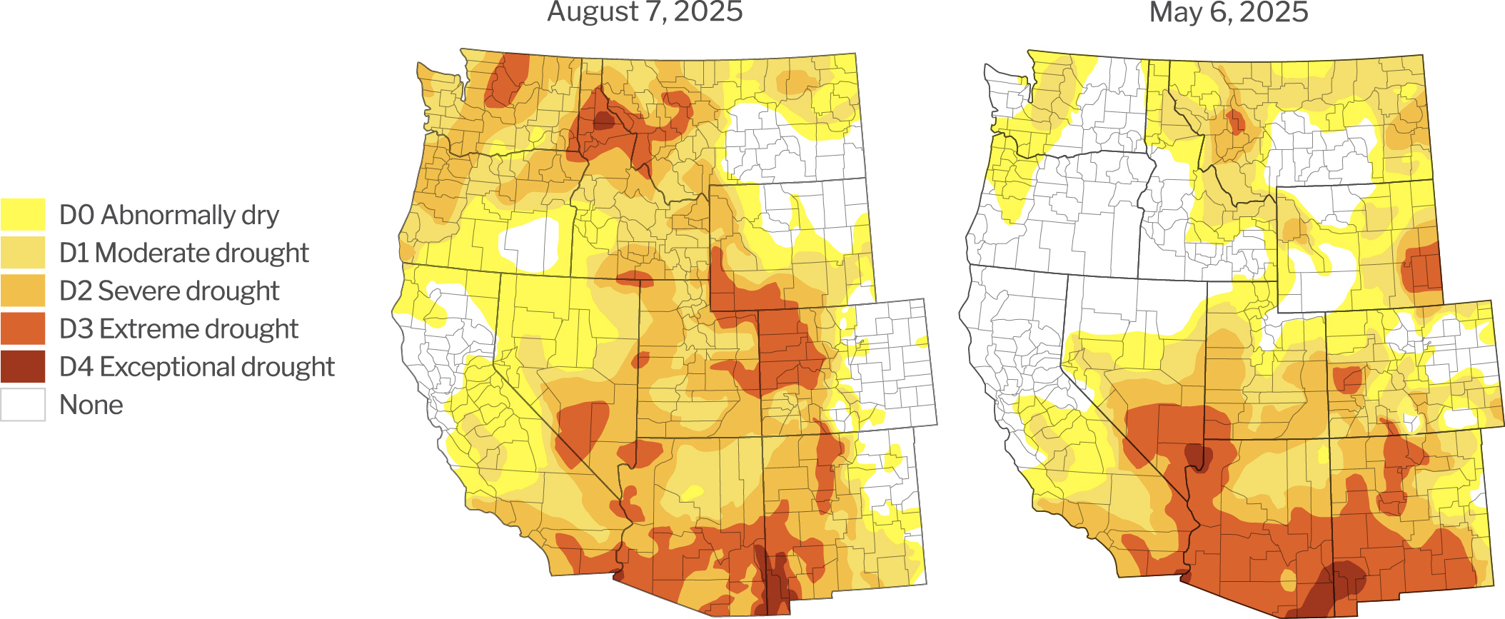
Source: U.S. Drought Monitor, University of Nebraska.
Description – The U.S. Drought Monitor provides a comprehensive look at drought conditions across the U.S., categorizing areas by intensity (no drought to exceptional drought). This tool helps agriculture producers understand water availability and make informed decisions about crop management.
Year-to-date precipitation
Year-to-date precipitation levels (Oct. 1 – August 6, 2025) are mixed across the West. While Oregon, Southwest Idaho and the eastern half of Montana are at/above their historical average, the remainder of the West is largely below average. Arizona faces the most acute situation, with some areas as low as 45% of average.
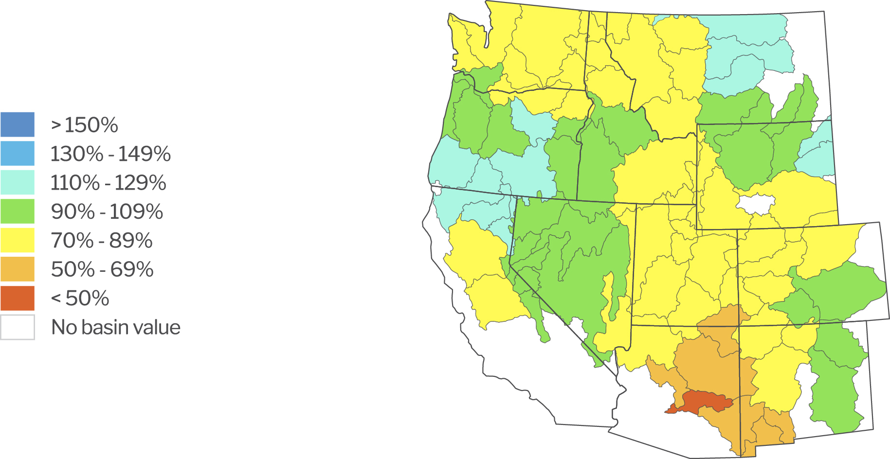
Source: Natural Resources Conservation Service. NWCC Interactive Map. Data as of August 6, 2025.
Description – The NWCC Year-to-Date Precipitation Map provides a detailed overview of precipitation levels across the U.S., comparing current data to a historical average. Similar to the Drought Monitor, this tool helps agriculture producers understand water availability and make informed decisions about crop management.
Reservoirs with low water levels
Several reservoirs fell notably below their average levels over the last three months. The Yakima River Basin in particular faces an acute water shortage, with the Cle Elum and Keechelus reservoirs falling to 32% and 26%, respectively. While the West has largely avoided extreme heat this season, dry conditions are pressuring water availability.
Reservoirs with water levels below 80% of their historical average
| Location/Region | Reservoir | Percent of average level | Percent of previous year |
|---|---|---|---|
| Colorado River Basin | Lake Powell | 46% | 51% |
| Lake Mead | 51% | 94% | |
| Deschutes River Basin, OR | Crescent Lake | 48% | 171% |
| Fourmile Lake | 59% | 150% | |
| Upper Snake River Basin, ID | American Falls | 47% | 43% |
| Island Park | 65% | 77% | |
| Grassy Lake | 74% | 102% | |
| Little Wood | 66% | 60% | |
| Lewiston Orchards | Reservoir A | 65% | 70% |
| Soldiers Meadow | 69% | 79% | |
| Yakima River Basin, WA | Cle Elum | 32% | 67% |
| Kachess | 60% | 92% | |
| Keechelus | 26% | 69% |
Data as of August 6, 2025.
Source: Bureau of Reclamation: Reservoir Storage. California Department of Water Resources. Arizona Department of Water Resources.
Description – Reservoirs are an important source of water for agriculture producers throughout the West. This section identifies those with water levels at 80% or below of their historical average for the given period. Reservoirs at or above 80% of their historical average water levels are not included in this list.
Updates impacting water access
Arizona
Drought conditions improved slightly in Arizona over the last three months. Improvement from extreme (D3) to severe (D2) drought was observed through the southern half of the state. The Normalized Difference Vegetation Index (NDVI), a measure of vegetation growth, is very low for this time of year. This is likely the result of both drought and an increase in regulatory pressure on water usage.
There’s apparent progress in Colorado River negotiations. The Colorado River Compact, an agreement that manages water allocations to lower basin states (Arizona, California and Nevada) and upper basin states (Colorado, New Mexico, Utah and Wyoming), expires in 2026. The newly proposed system would allocate water based on projected “natural flows” (as if unimpeded by dams), to be determined by a three-year average. This approach better recognizes the current water situation and offers a more equitable approach.
Governor Katie Hobbs signed Senate Bill 1611, or the Ag-to-Urban bill, which allows home developers in Pinal and Maricopa Active Management Areas to use groundwater credits from voluntarily retired agricultural lands. The bill strikes a balance between 1) conserving water resources, 2) increasing the supply of homes near Phoenix and Tucson and 3) allowing producers who would like to retire to do so while capitalizing on their land.
Senate Bill 1520 passed out of the House Natural Resources, Energy and Water Committee on March 25, but negotiations remain ongoing in the Legislature. The bill would allow the creation of Basin Management Areas (BMA) designed to conserve groundwater in Gila Bend, Hualapai Valley and the Willcox Groundwater Basin. A point of contention is in determining how much groundwater pumping should be reduced.
Arizona Attorney General (AG) Kris Mayes filed a suit against Fondomonte, a Saudi owned alfalfa farm, stating that excessive groundwater pumping is negatively impacting others in the area. While the farm is operating within existing statues, the AG’s argument is based on the idea that it’s violating the state’s public nuisance law. On one hand, challengers argue this action could set new precedent and put other farms at risk of legal action. On the other, supporters argue that Fondomonte is taking advantage of the region’s lack of regulation and their practices have depleted local wells and led to land subsidence.
California
The California Department of Water Resources (DWR) increased State Water Project (SWP) allocations from 40% to 50% of contracted supply. The U.S. Bureau of Reclamation (USBR) increased Central Vally Project (CVP) allocations for South of Delta contractors from 50% to 55%. SWP and CVP storage and delivery systems provide the vast majority of water to agriculture and urban areas.
Several locations are either implementing or proposing groundwater use fees to fund monitoring and management costs:
- California State Water Resources Control Board (SWRCB) proposed a new fee schedule for growers in the Tule Subbasin ranging from $5-$40 per acre-foot based on total pumping. Producers already face usage fees by individual Groundwater Sustainability Agencies (GSA) across the subbasin and argue SWRCB’s proposal inadvertently puts the cost of statewide monitoring and enforcement on them.
- Vina GSA implemented a new fee schedule, including $12.62 per parcel plus $4.22 per cropped acre for agricultural users or 96 cents per developed parcel for municipal/domestic users. Fees will support reporting and data management requirements by the Sustainable Groundwater Management Act (SGMA).
- The Monterey County Water Resources Agency (MCWRA), in coordination with Salinas Valley Basin Groundwater Sustainability (SVBGSA), may institute well-use fees in Salinas Valley. These fees would fund monitoring and managing activities for both agencies and range from $140 - $280.
- The Paso Robles Area Groundwater Authority (PRAGA) is proposing groundwater use fees primarily for agriculture, commercial and public water system pumpers. Possible fee rates have not been announced. Rural domestic well owners pumping less than 2 acre-feet per year would be exempt.
SWRCB announced that the Chowchilla subbasins’ revised groundwater sustainability plans (GSPs) were sufficient to avoid probation under SGMA. (Tule is the only subbasin under probation.) Oversight of Chowchilla was returned to DWR, and reports suggests Kaweah is expected to follow.
Agriculture water districts in the Kern groundwater subbasin have begun approving amendments to improve groundwater levels, protection for drinking water wells and community engagement. The updated GSP was resubmitted to the state Water Resources Control Board and is awaiting approval. The Kern groundwater subbasin risks probation.
The Imperial Irrigation District (IID) Board of Directors approved the 2025 Deficit Irrigation Program, a voluntary initiative to address the drought crisis in the Colorado River Basin. The program compensates local growers ($300 per acre-foot) for reducing water use by temporarily fallowing fields or limiting irrigation, aiming to conserve water amid ongoing drought conditions. The IID updated the program description and formalized participation terms to support conservation efforts while maintaining agricultural productivity.
Idaho
Drought conditions increased significantly throughout the state over the last three months, with extreme drought (D3) expansion observed in the north and south. Magic Valley and Eastern Idaho are predominantly in severe drought (D2). Anecdotal reports suggest soil moisture is below average for certain areas. Vegetation growth, as measured by NDVI, started the season strong but began declining mid-June. Growth is now notably below average. Reservoir levels are near average levels.
Adjudications are a priority right now and occurring extensively throughout the state. Adjudication is a formal process to evaluate water resources, who uses them and how they are used. In a recent interview, the Idaho Department of Water Resources (IDWR) director affirmed this point, stating that water districts in all adjudicated basins need to be created to ensure compliance with law.
Oregon
Drought conditions expanded significantly throughout Oregon over the last three months, with much of the northern half of the state and coastal regions under severe (D2) to extreme (D3) classifications. The remainder of the state is classified as abnormally dry.
Lawmakers passed Senate Bill 1154, which streamlines how the state can respond following the identification of contaminants in groundwater. The bill gives state agencies greater authority to act when groundwater contamination is identified. Following significant pushback from private well owners and agriculture groups, the final bill was revised to limit the state’s enforcement authority relative to the initial draft. Still, this bill may increase compliance costs and reduce consumption for groundwater users, including agricultural producers.
The Oregon Water Resources Department (OWRD) is preparing to issue new rules to govern groundwater use in the Harney Basin. These may include designating the area as a Critical Groundwater Area and requiring water rights holders to install measuring devices and report water use annually. New groundwater uses would be restricted to non-consumptive geothermal uses, among other exemptions. These proposed rules are currently open for public comment.
Montana
Drought conditions expanded throughout Montana over the last three months, with most of the western and northern portions of the state under severe (D2) to extreme (D3) classification. The state experienced widespread, significant rainstorms in the second half of June and in mid-July. Much of central and eastern Montana received approximately one inch of rain on July 15 alone. This improved drought conditions some, particularly in the north-central part of the state. Even so, some irrigation projects will be shutting off irrigation water early this year. Soil conditions remain dry, though NDVI levels are near their average.
Montana recently signed into law a repeal of numeric standards for nutrient runoff into water, particularly for nitrogen and phosphorus. (Nutrient runoff can lead to algae overgrowth and impact local fish and wildlife populations.) In response, the conservation organization Upper Missouri Waterkeeper sent a petition to the U.S. Environmental Protection Agency (EPA) requesting to review and reject changes to Montana’s updated water quality standards. States are required to meet the EPA’s water quality standards as outlined in the Clean Water Act.
Water levels at Little Bitterroot Lake are very low due to inadequate rain runoff and there are concerns as to whether it can meet irrigation requirements. Flathead County commissioners have engaged the Bureau of Indian Affairs to better understand current conditions. Little Bitterroot Lake is the largest reservoir in the Camas Water District.
The St. Mary Siphon Repair Project hit a milestone by restoring water flow to the Milk River, which provides both drinking and irrigation water. This project came in response to siphon failures back in June 2024 and is currently three months ahead of schedule.
Washington
Washington’s Department of Ecology (Ecology) has issued Drought Emergency Declarations throughout most of the counties in or near the Cascade Range. This declaration triggers emergency relief options for water users.
USBR reports the storage in the Yakima basin is at 62% of average as of July 17. Senior rights holders will receive 100% of their allocations, while those with junior rights will be at 40% with further reductions possible. Lack of rain and snowpack has led to one of the most severe water shortages on record for this area. Roza Irrigation District plans to stop three to four weeks early. Water is normally delivered until about Oct. 20.
The Nooksack Basin Water Resource Inventory Area (WRIA) is going through an adjudication process. (WRIAs are higher elevation locations that funnel rain and snowmelt into streams, tributaries and rivers.) Claimants include those who withdraw water from a well or divert water from a stream or lake in WRIA 1, except customers of a city or group water system. It also includes those whose wells fall under a permit-exempt status. Agriculture producers are concerned this process will reduce their access to water. The Yakima Water Rights Adjudication, which took place from 1977 to 2019, resulted in a 9% decline of irrigated farm acreage in Yakima County.
Return to Customer Stories home page.